
In October 2009, my mother and I, and the four dogs, began a venture that would end up taking us on a journey throughout the western half of the state of Oregon. Our goal was to visit all of Oregon's covered bridges. We accomplished this goal in six weekend day trips. I have divided the covered bridges into nine regions.
Here is what we discovered in the
SOUTHERN REGION.
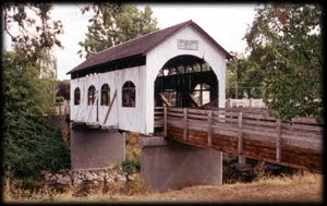
Grave Creek Covered Bridge

Josephine County
The Grave Creek Covered Bridge was built in 1920 with a Howe truss design and spans 105 feet across Grave Creek.

Features of the wooden structure include six gothic style windows on either side, concrete abutments, a Howe truss, rounded portals and a shake roof.
 The old wooden river crossing was the last covered bridge on the North/South Pacific Highway system.

Existing records on the Grave Creek Bridge show a contract awarded by the Oregon State Highway Department to J. Elmer Nelson in April 1920.

Features of the wooden structure include six gothic style windows on either side, concrete abutments, a Howe truss, rounded portals and a shake roof.


Existing records on the Grave Creek Bridge show a contract awarded by the Oregon State Highway Department to J. Elmer Nelson in April 1920.
The bridge is the last existing covered bridge in Josephine County.
 The Grave Creek Covered Bridge is one of the best examples of a country preserved covered bridge.

Hidden between the Smith Hill Summit to the north and the infamous Sexton Mountain Pass to the south, the picturious Sunny Valley and covered bridge has the appearance of a life size train set with fall decorated trees dotting the landscape.


To get there from Grants Pass, travel 15 miles north on Interstate 5 to Sunny Valley, exit 71. Turn left at Sunny Valley Loop Road and continue north for about one mile. The Grave Creek Covered Bridge can be seen from I-5 and is approximately 0.25 miles from the highway.


Hidden between the Smith Hill Summit to the north and the infamous Sexton Mountain Pass to the south, the picturious Sunny Valley and covered bridge has the appearance of a life size train set with fall decorated trees dotting the landscape.

Only thing missing is the train and tracks. They pass through this small valley about a mile to the west.

To get there from Grants Pass, travel 15 miles north on Interstate 5 to Sunny Valley, exit 71. Turn left at Sunny Valley Loop Road and continue north for about one mile. The Grave Creek Covered Bridge can be seen from I-5 and is approximately 0.25 miles from the highway.
____________________
Wimer Covered Bridge

World Guide Number: 37-15-02
Jackson County
The "old" Wimer Covered Bridge was build in 1927 with the Queenpost truss design and spans 85 feet across Evans Creek. But on July 6, 2003, the Wimer Covered Bridge collapsed.

On a hot summer afternoon, in the quiet community of Wimer, Oregon, local residents were startled to hear a giant crashing sound coming from the vicinity of their covered bridge. Customers at the Wimer Market, only a dozen paces away, rushed out to witness the unthinkable. The historic Wimer Covered Bridge in Southern Oregon had spontaneously collapsed into Evans Creek.

The July 6, 2003 incident shocked and saddened a community. The weekly Rogue River Press expressed what many residents felt with the simple headline in its next issue: “It’s Gone!” The bridge collapsed due to extensive decay in the bottom chord at a panel point on the upstream truss.
The small community of Wimer, Oregon immediately started the process of rebuilding their beloved bridge. After years of planning and fund raising construction started on the new structure.

The community rallied and rebuilt the Wimer Covered Bridge.

On July 6, 2008, five years after the collapse, the new Wimer Covered Bridge was reopened with a city wide celebration including evening fireworks.

Features of the new Wimer covered span include a shingle roof, the usual daylighting narrow windows above the trusses, asphalt flooring, and now a Howe truss design instead of the Queenpost truss.

The bridge appears not unlike a barn from downstream and only the flying buttresses indicate it to be a covered bridge and not a barn over water.

The Wimer Covered Bridge is Oregon's newest covered bridge. A "redesigned" replica of the historic original covered bridge. We crossed the bridge and stopped at the little market ajacent to the bridge. We bought some sweet snack.

To get there, take I-5 exit 48 at the small town of Rogue River. Travel north on East Evans Creek Road to the small town of Wimer. The Wimer Covered Bridge is located next to the city market.
______________________________
Antelope Covered Bridge
Jackson County
The bridge originally was built in 1922 and spanned Antelope Creek some 10 miles southeast of Eagle Point. In August 1987, the structure was loaded onto a makeshift trailer and volunteers hauled it to the city of Eagle Point.
The Antelope Creek Bridge was built with a Queenpost truss and now spans 58 feet across Little Butte Creek.
 When the bridge was rebuilt at the new site, arched openings were cut into each side so school kids could be watched as they crossed the span.

This alteration caused the bridge to be removed from the National Register of Historic Places. Since then, the bridge has been re-sided in a fashion that represents the original design. Now only ribbon openings appear under the eves.
 While we were visiting the Antelope Covered Bridge, there was a group of juvenile delinquents gathered inside the bridge smoking pot. We waited some time for the kids to leave so pictures of the bridge could be taken without people. They didn't budge until a police car drove by. They immediately scattered at the site of police. Once the "coast-was-clear" they returned to the hidden walls and resumed their illegal activity.
City's officials wanted window's in the bridge, to watch such delinquents, but because of the "importance" of preserving history, the positive ways of these kid's futures lie in jeopardy.
 I expressed my concerns regarding the drug use and irresponsible activity within the bridge to Leon Sherman, the mayor and retired police chief of Eagle Point. Sherman reassured to me that efforts have been made to hamper the misuse of the bridge. He said, "proper funding has been reduced or eliminated all together that could help monitor the bridge's activity." Sherman also expressed his frustrations regarding the political jargon that has taken place over the years as to how to resolve the youth's misuse of the bridge. Sherman said, "the nearby school can't do anything, because the bridge is not on school grounds. We lost two officers due to budget cuts. The historical society demands proper preservation, old working policies were dismissed." Political jargon.
Once funding is in place, Sherman said, "the next step is to install surveillance camera's in and near the bridge will help curtail such poor judgement activity."
The preservation of history is important, but is it worth risking the future of these fallen youth? If windows would help, then why not alter the bridge to preserve and protect the future?
 Mayor Sherman is moving in the right direction. I believe he has the historic past and the future of his town's youth in his best interest.


This alteration caused the bridge to be removed from the National Register of Historic Places. Since then, the bridge has been re-sided in a fashion that represents the original design. Now only ribbon openings appear under the eves.

City's officials wanted window's in the bridge, to watch such delinquents, but because of the "importance" of preserving history, the positive ways of these kid's futures lie in jeopardy.

Once funding is in place, Sherman said, "the next step is to install surveillance camera's in and near the bridge will help curtail such poor judgement activity."
The preservation of history is important, but is it worth risking the future of these fallen youth? If windows would help, then why not alter the bridge to preserve and protect the future?

To get the Antelope Covered Bridge from Highway 62 in Eagle Point, turn east onto Linn Road (sign points to Eagle Point and Klamath Falls). Travel to South Buchanan Street and turn left. Turn right onto West Main Street and continue to Royal Avenue. The bridge is located in the city of Eagle Point at the intersection of Main Street and Royal Avenue.
___________________________
Lost Creek Covered Bridge

Jackson County
The Lost Creek Bridge, at 39 feet, is the shortest of all Oregon covered bridges. The bridge was build with a Queenpost truss and crosses the seasonal Lost Creek. Since 1979, the structure has been closed to traffic.

Many Jackson County residents, including Shirley Stone, daughter of pioneer John Walch, claim the Lost Creek Bridge to have been built as early as 1878-1881. If authenticated, this would make the Lost Creek Covered Bridge, Oregon's oldest standing covered bridge.

The span may have been partially or totally rebuilt in 1919, hence the official construction date in that year. Features of the bridge include the usual county Queenpost design, a shingle roof and flying buttress braces.

The rough wooden flooring consists of diagonal planking, which bears the history of wagon track creases permanently gouged into the wood flooring.

The gouges were very evident. History seen at its best.

The Walch Memorial Wayside Park abuts the bridge site. Descendants of John and Marie Newsome Walch built and maintain the park, which includes picnic tables, a bandstand, cooking areas, manicured flower gardens and an outhouse built in the 1930's by Tom Stanely. After 80 plus years, the outhouse is still usable.

At least I hope it is still usable?

The bridge was nearly lost in the 1964 Christmas flood. As swirling waters and heavy debris lashed at its piers, residents and concerned bridge enthusiasts prayed during the night that the bridge would be saved.

According to a local newspaper, the skies opened and the water receded as morning came. The Lost Creek Covered Bridge was not "lost". The journalist questioned, "Was the bridge saved by prayer?"

To get there from Eagle Point, continue southeast on Royal Avenue to Highway 140. Alternately, travel east on Highway 140 from Highway 62, (Crater Lake Highway.) Continue on Highway 140 to Lake Creek Loop Road. From Lake Creek Loop Road, travel south through the community of Lake Creek on South Fork Little Butte Creek Road. Turn south on Lost Creek Road and continue approximately one half mile. Lost Creek Bridge is 4 miles south of Lake Creek.
_____________________________
McKee Covered Bridge

Jackson County
The McKee Covered Bridge was built in 1917 with the Howe truss design and spans 122 feet across the Applegate River.
 "We made it."
The rustic, well-known covered bridge spanning the Applegate River, just eight miles from the California border is the most southerly covered bridge in Oregon.

(photo by my mother)
The Applegate River is a 51-mile long tributary of the Rogue River. It drains forested foothills of the Siskiyou Mountains along the Oregon-California border. The river is one of Oregon's 'north' flowing rivers.
 The McKee Covered Bridge was used from 1917 to 1956, originally serving the mining and logging traffic. In 1956, the bridge was declared unsafe for vehicle traffic.
 Features of the McKee Bridge include a Howe truss design, flying buttresses, open daylight windows at the roofline, and a shingle roof.


The rustic, well-known covered bridge spanning the Applegate River, just eight miles from the California border is the most southerly covered bridge in Oregon.

(photo by my mother)
The Applegate River is a 51-mile long tributary of the Rogue River. It drains forested foothills of the Siskiyou Mountains along the Oregon-California border. The river is one of Oregon's 'north' flowing rivers.


Lindsay Applegate, for whom the river is named, prospected the area on the way to the mines in California.

The discovery of prosperous mines caused a north-south route to be developed in the area, and the covered bridge was used as a rest stop because it was halfway between Jacksonville and the Blue Ledge Cooper Mine to the south.

We called the McKee Covered Bridge, "the bridge to nowhere." You're able to walk across the bridge, but a short distance beyond the other side, you're blocked by private property.

Though we were a bit disappointed with the McKee Covered Bridge with the lack of vantage photo locations, the drive out too the bridge through the Applegate Valley and foothills of the Siskiyou Mountains was very scenic.
To get there from Medford travel west on Highway 238 through Jacksonville to the little 'town' of Ruch. From Ruch head south on Applegate Road for approximately 8.5 miles.
__________________________
Buncom
Southern Oregon ghost town
 Before heading home, we took a side route to visit the last remaining historic ghost town in southern Oregon.


(post office and general store)
 (cookhouse)
Then in 1990 the property was purchased by Reeve and Lyn Hennion, and with the enthusiastic help of neighbors and friends, the Buncom Historical Society was established to preserve the site and area history.
 (bunkhouse)
To get there from Medford, take Highway 238 west, through Jacksonville and travel another eight miles to the little community of Ruch. Turn left where the signs direct you to Valley View Winery and Applegate Lake. Go three miles south on Upper Applegate till you reach Little Applegate Road. Turn left on Little Applegate and go three miles to the intersection of Sterling Creek Road. You're in Buncom.

Though we were a bit disappointed with the McKee Covered Bridge with the lack of vantage photo locations, the drive out too the bridge through the Applegate Valley and foothills of the Siskiyou Mountains was very scenic.
To get there from Medford travel west on Highway 238 through Jacksonville to the little 'town' of Ruch. From Ruch head south on Applegate Road for approximately 8.5 miles.
__________________________
Buncom
Southern Oregon ghost town


Hidden among the pines in a corner of Southern Oregon's Applegate Valley, the ghost town of Buncom provides a look back into the past, to the days when gold miners swarmed the hills.

(artwork by Tony Oliver)
The three buildings at Buncom are all that remains of a once thriving gold mining camp. When gold was discovered on Sterling Creek in 1854, thousands of miners flocked there from the gold fields of California and other Oregon locations. Many of them made their fortunes, but most didn't.

The mining claims soon were consolidated and run by large companies, but Buncom found a second life. Since it was a day's wagon ride from Jacksonville, the nearest town, Buncom became the supply and distribution center for the farmers and ranchers in the Little Applegate Valley. A stagecoach route ran through it, and the federal government made Buncom a post office in 1896.

(post office and general store)
Mom and Maxx check out the ghostly post office to find nobody home...or is there?

The coming of the automobile was the end for Buncom. With Jacksonville and Medford now just a short drive away, there no longer was a need for Buncom.
 The post office closed in 1916, and while a small general store continued to operate much like a convenience store today, the buildings were eventually abandoned and fell into disrepair.


Then in 1990 the property was purchased by Reeve and Lyn Hennion, and with the enthusiastic help of neighbors and friends, the Buncom Historical Society was established to preserve the site and area history.

To get there from Medford, take Highway 238 west, through Jacksonville and travel another eight miles to the little community of Ruch. Turn left where the signs direct you to Valley View Winery and Applegate Lake. Go three miles south on Upper Applegate till you reach Little Applegate Road. Turn left on Little Applegate and go three miles to the intersection of Sterling Creek Road. You're in Buncom.
No comments:
Post a Comment