
"Where the Cascades remain unknown"
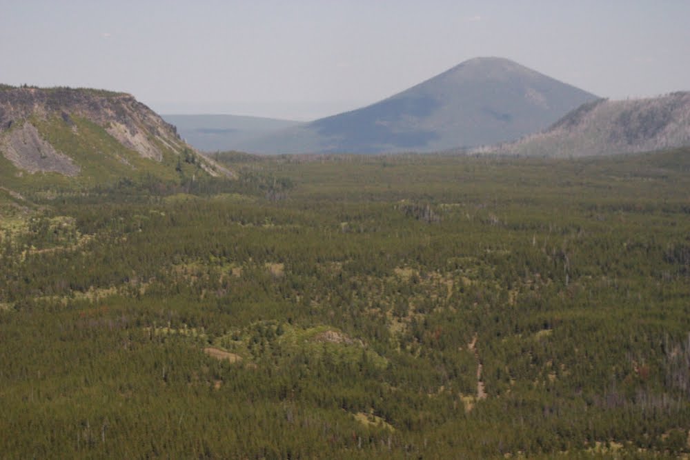
Located near the Santiam Pass summit in the Oregon Cascades, Sand Mountain is the highest point (5460’) in the Sand Mountain Volcanic Alignment.
"Beauty is always visible, but it is up to us to see it."
Located near the Santiam Pass summit in the Oregon Cascades, Sand Mountain is the highest point (5460’) in the Sand Mountain Volcanic Alignment.
"Beauty is always visible, but it is up to us to see it."

The Volcanic Alignment, which consists of more than 20 unknown cinder cones and miles of lava flows, represents some of Oregon’s most recent volcanic activity.

The Sand Mountain Alignment volcanic activity is responsible for some of Oregon's most dramatic Cascade scenery.


Lava flows from Sand Mountain dammed the headwaters of the McKenzie River to form Clear Lake, drowning a forest well preserved by the icy cold waters of the lake.

Pyroclastic flows, from the Sand Mountain Volcanic Alignment, filled the high Cascade valley's creating a thick gradually sloping coarse rocky volcanic plain which acts as a giant filter for rain and snowmelt.

Rain and snow melt slowly moves underground through this rocky coarse rock until it emerges in a giant, cold spring in Clear Lake to the west.

It is said that for the water to journey from the surface near the Sand Mountain Alignment landscape to the Great Spring, it can take anywhere from 2 to 10 years to filter from one end to the other. Such a time frame is hard for me to comprehend.

(There is a more complicated scientific answer, but for the sake of this blog, I am able to accept the simple mineral content explanation from Bart Wills.)

Again, Mr. Wills answer, I liked. He explained that the law of gravity does not apply to water when underground. Record rains can fall and the excess water will filter through and fill aquifers’, but a rush of water is not likely to happen at the springs exit, much like you cannot force more water through a straw than what the straw can handle. The "flooded" aquifer will find additional exits through cracks in the earth and the excess water will exit from "seasonal" springs throughout the region.


Volcanic activity began at the north end of the Alignment and spread south along a fissure. Saywer’s Ice Cave is located in a Sand Mountain lava flow at the north end of the Alignment, and Sahalie Falls tumbles over one of the southernmost flows (newest lavas).

While these two natural landmarks, the Saywer's Ice Caves and Sahalie Falls, of the Alignment are well-known due to there proximity to Highway 126, ironically, the cinder cones which created them are far less known.

Today, the Sand Mountain Cinder Cones are protected as a nature preserve.
The only man-made disturbance on the cone sits atop the highest point on the south cone. There you'll find the Sand Mountain (fire) Lookout Watch Tower.
 The Sand Mountain Society (SMS) was formed in 1987 by a group of concerned citizens who felt that this off-road recreation was inappropriate for, and destructive to the terrain of the Sand Mountain Volcanic Alignment.

 The Sand Mountain Lookout was restored to the summit of South Sand Mountain in 1989 after a 20-year absence.
 The model partnership between the Sand Mountain Society and the Willamette National Forest is still protecting the area today while offering interpretive services to the public.
 Together the Sand Mountain Society, (SMS) and the Forest Service relocated an abandoned fire lookout from Whisky Peak in southern Oregon, which was kindly donated by the Rogue River National Forest.
 The lookout replica watches over the Geological Special Interest Area. This unusual volcanic phenomenon can be easily viewed from the summit.


In the photo above, the well known 10,497 foot Mount Jefferson rules the land to the north, and the not so well known 6,229 foot Maxwell Butte rises in the distance...and the north cone of Sand Mountain is shadowed in the foreground.
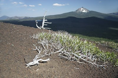
 The mysterious 7,844 foot Three Finger Jack volcanic peak dominates the skyline to the northeast.
The grey colored forest is the remains of the 2003 B&B forest fire.
 A grand view from Sand Mountain, of 7,794 foot Mount Washington rises sharply to the East.
 From the crater rim of Sand Mountain, the ever popular 10K+ Three Sisters looms in the distant southeast.

The only man-made disturbance on the cone sits atop the highest point on the south cone. There you'll find the Sand Mountain (fire) Lookout Watch Tower.


Forest Service officials agreed, and they designated Sand Mountain a Geologic Special Interest Area with attendant protections.


Some of the most stunning views of the Central Oregon Cascade volcanoes, from Mt. Hood to the north to Diamond Peak to the south, can be seen from the Sand Mountain Fire Lookout Tower.


The grey colored forest is the remains of the 2003 B&B forest fire.


Other geologic features visible from the Sand Mountain summit include, but are not limited too, the barren Black Sand Flats, or "Black Sand Lake".

I found this unique feature to be very mysterious. An area the size of a football field lay barren without plant life.
 As if there was a distinguishable shoreline, the "Black Lake" was once an ATV's dream sand pit.
 Now apart of the protected lands, the "Black Lake" has been restored to its former mysterious oddity.
 In the photo below, the popular winter ski resort of 5,702 foot Hoodoo Butte looms.

In the photo below, the rare 5,523 foot Hayrick Butte is visible just south of Hoodoo Butte.

Hayrick Butte is a tuya volcano rising 5,523 above sea level.
A tuya is a type of subglacial volcano, formed when lava erupts underneath an overlying glacier or ice sheet and then melts through to the surface and pools, producing the flat plateau on top with near-vertical walls along the ice-contact margin as the lava cools and hardens. Hayrick Butte is one of the most perfectly formed examples of a tuya volcano in the contiguous United States, with a nearly-flat triangular plateau about 0.5 miles across and steep walls rising about 700 ft above the plain below. Tuya volcanoes are only found in Iceland, British Columbia, the Antarctic Peninsula, and the Santiam Pass region in Oregon.
 Due east of Sand Mountain you'll see in the distance, the 6,436 foot Black Butte. (Hayrick Butte is in the left part of the photo.)
 Belknap Crater, the Husband, and Todd Butte are also nicely viewed in the south from Sand Mountain.
 (Western White Pine ~ Pinus monticola)
The Alignment Cones offer beautiful volcanic slopes with a remarkable array of flora which includes wildflowers. One very little delicate flower growing all over on Sand Mountain in July is the Calyptridium umbellatum, or commonly known as the Pussy-Paw.
 The Pussy-Paw flower consist of a pink cluster of densely packed flowers on prostrate stems resembling an upturned pads of a cat's foot. (I personally didn't see the resemblance to a cat's foot, but it must be true.)
 Pussy-Paws grow in sandy areas, an appropriate flower to grow on Sand Mountain. This low growing plant raises its flower stems each morning and lowers them in the evening, but why it does this is a mystery. Maybe, by the end of the day the flower stem get's tired and its energy is weak by the end of the day?
Some other wildflowers I found on Sand Mountain included:

 Not sure what this little leafed plant is?
 (Miniature lupine ~ Lupinus bicolor)

 (Marum-leaved buckwheat ~ Eriogonum marifolium)
Though Sand Mountain has a nice collection of unique wildflowers, If a mascot had to be chosen, the Sand Mountain mascot would definately go to, hands-down, to the Pygmy Short-horned lizards, Phrynosoma Tapaja douglasii, also referred to as a horny toad or horned frog.
 I learned that the summit of Sand Mountain is the furthest location west of the Cascade crest to find them. This is a sub-species endemic to the Northwest region, differing slightly from Horned lizards in the desert Southwest, but they share a significant trait with their relatives: they like it dry.
 Abundant in the more arid expanses east of the Cascade Mountains, the western slopes are generally too timbered, overgrown and wet. But the windswept summits of these somewhat unlikely cinder cones are considered sub-alpine, xeric landscapes, and therefore suitable to their habitat.
 Their survival story is quite unique but simple...instead of fleeing or taking "flight" in the presence of danger, their instinct is to stay motionless and blend in with their surroundings. It’s true, it is very hard to distinguish them from the cinder gravels on the summit, until they move. If it wasn't for the Lookout Tower-man on duty, Tim, a professor from Portland, I wouldn't have even known the little camoflagued creatures were even there. Once discovered, it was easy to get close enough and photograph one because it instinctly remained motionless upon my approach to it. Though Sand Mountain has an abundant little horned lizards, I saw only three while on the summit.
 (Mountain Hemlock ~ Tsuga mertensiana)
I have travelled the Santiam Highway many times, but not until recent have I actually stopped to "smell the roses" along the way.
 Little did I know such a unique, bizzare, fascinating and mysterious landscape existed.


In the photo below, the rare 5,523 foot Hayrick Butte is visible just south of Hoodoo Butte.

Hayrick Butte is a tuya volcano rising 5,523 above sea level.
A tuya is a type of subglacial volcano, formed when lava erupts underneath an overlying glacier or ice sheet and then melts through to the surface and pools, producing the flat plateau on top with near-vertical walls along the ice-contact margin as the lava cools and hardens. Hayrick Butte is one of the most perfectly formed examples of a tuya volcano in the contiguous United States, with a nearly-flat triangular plateau about 0.5 miles across and steep walls rising about 700 ft above the plain below. Tuya volcanoes are only found in Iceland, British Columbia, the Antarctic Peninsula, and the Santiam Pass region in Oregon.


The Alignment Cones offer beautiful volcanic slopes with a remarkable array of flora which includes wildflowers. One very little delicate flower growing all over on Sand Mountain in July is the Calyptridium umbellatum, or commonly known as the Pussy-Paw.


(Desert Parsley ~ Lomatium hallii)

(Shrubby penstemon ~ Penstemon fruticosus)


(Alpine Aster ~ Aster alpinus)

Though Sand Mountain has a nice collection of unique wildflowers, If a mascot had to be chosen, the Sand Mountain mascot would definately go to, hands-down, to the Pygmy Short-horned lizards, Phrynosoma Tapaja douglasii, also referred to as a horny toad or horned frog.


I have travelled the Santiam Highway many times, but not until recent have I actually stopped to "smell the roses" along the way.


The Sand Mountain Alignment Geological Interest Area, and surrounding lands provides an incredible year round recreational experience. There is something there for everybody.

My dog Pynekone and I spent the entire day exploring the "simple" beauty found in and around the Sand Mountain Alignment.
 I don't think there is any other location where in one day you can explore powerful waterfalls, A sunken forest, an ice cave, miles of lava fields, a "Black Lake", countless cinder buttes, a Tyru volcano, dramatic Cascade peak vistas', delecate wildflowers, a lookout tower, a pygmy lizard, a ski resort, an alpine lake or two, and the historic Santiam Wagon Road.


Pynekone enjoyed the constant cool breeze on the top of Sand Mountain.

1 comment:
Steve, this is amazing!! Your pics are gorgeous and the scenery is breathtaking- you rock!! Seth and Michele
Post a Comment